‘Eastward [from Guy’s Hospital] is a poverty-stricken region called the Maze, and a Roman Catholic Chapel and Convent, where the ceremony of taking the veil may be occasionally witnessed..’.
I believe there was a 14C manor called The Maze. ‘..The property was bounded to the south by Weston Street, Weston Place, Melior Street, Great Maze Pond and Maze Pond. In 1555 it was described as comprising a mansion house, 17 small tenements and an alley (Carlin 1996, 64)…’. From 1623 the manor was owned by the Weston family. An archaeological assessment of the area describes the development of low-quality housing, ‘rents’, during the 19C. Bombing during WWII seriously damaged the area which is now under redevelopment again, in association with the landowner, the Diocese of Southwark.


I think the Roman Catholic Chapel and Convent to which Bradshaw refers may be that of the Sisters of Mercy (1838). Pugin designed the Convent, the first of his convents, and the Chapel was by Kempthorne. The buildings were destroyed in WWII and rebuilt after the war. The Convent of Mercy appears a simple building but the church of the Holy Trinity, Dockhead, an ‘eclectic’ (Pevsner) building by HS Goodhart-Rendel completed in 1959, seems to me beautifully crafted.


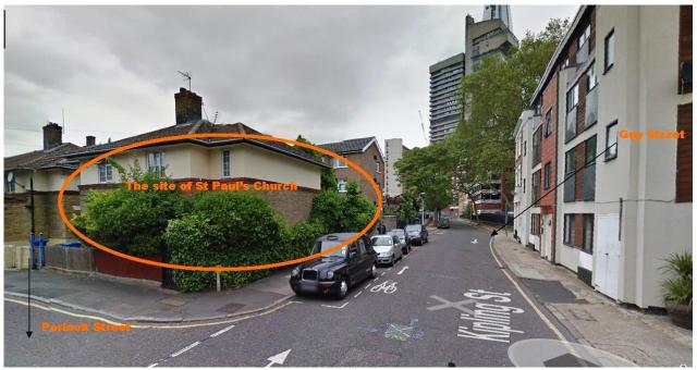
‘..St Paul’s Church in that district was finished in 1841..’ and I think this refers to the church in Kipling Street. It was built by Samuel Teulon and very popular for weddings. However, the church was bombed in WWII and demolished in 1961. Today the area is rebuilt and I couldn’t find any indication of where the church might have stood. But thanks to runner500 and Google Maps I can now pinpoint the site.


You may be interested in
Old St Nicol
The Mint
St Paul’s Church (photograph & interesting article)
The churches of Samuel Teulon
Pugin and the design and development of Roman Catholic institutions
The Maze Manor and a history of Southwark and here and here
runner500
That’s really interesting, I don’t know where either of these maps are of any help in locating the church
http://www.ideal-homes.org.uk/__data/assets/image/0010/273655/map-01053-2000.jpg
http://maps.nls.uk/view/101201655
Candy Blackham
Wow! I didn’t know about the maps.nls – what an amazing resource – thank you so much. Sheet VII.87 clearly shows the location of the Convent and Chapel of the Sisters of Mercy and it is slightly changed from today. And I found St Paul’s Church on the map and have amended the post.
runner500
Glad it was of help – the NLS resource is fantastic isn’t it? One other source I forgot about is the LB Southwark Historical Mapping site
http://maps.southwark.gov.uk/connect/southwark.jsp?mapcfg=Historical_Selection&tooltip=Hist_tips